Béziers' ancient Maps
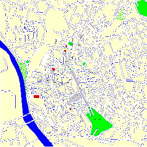
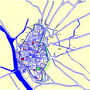
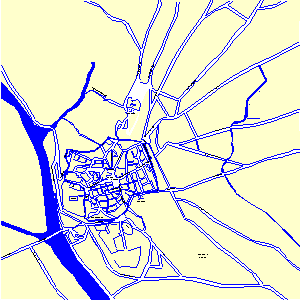
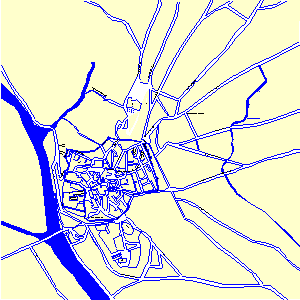
Plans are superposables, allowing so to see the evolution of the city following times.
Fortifications are colored in brown. I think the tracings are correct, as well as the various doors of the XV-th's map. On the other hand, I do not guarantee the exactness of the internal tracing of the city. This one has, indeed, undergone numerous alterations during centuries. I have extrapolated especially for the III-th century Roman map, although the axes of the streets : Rue Française / Casimir Peret, 4 Septembre / Viennet, even Rue d'en Vedel / rue des anciens Combattants, remained the same in the course of time and without forgetting the Domitian way which crosses our city on both sides. Romans firsts had reorganized the city; then in 1209, it was burned in large part and reconstructed. Under François 1er, wooden houses were demolished, considered unhealthy and dangerous.
Finally new axes were drilled in 1894 : la rue de la République and l'avenue Alphonse Mas (national street). It is interesting to note that if some axes remained, in particular at the east of the city : the Domitian way / avenue Saint Saëns and Avenue Clémenceau, others are not used on the west side as the entrance through Canterelles or Tourventouse. The biggest "loss" is certainly the axis of the street Française/Casimir Perret (former street Straight) which connected the heart of the city - marketplace, in front of the City hall - to its symbolic heart : the Saint Aphrodise's church.
|
|
|
|
Map of Béziers III-rd century in JPG |
Map of Béziers X-th century in JPG |
OTHERS MAPS
Map of Béziers end XIX-th century
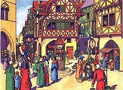
To have an idea of what the city's center looked like in the XIV-th century, here is a passage of some articles, "Dix ans de Consulat à Béziers de 1384 à 1394", published in "l'Hérault" - a Friday weekly - by M.A. Baluffe : "Houses were small, low, pressed by their sides, like if they wanted to feel their elbows, packed on themselves as to escape from the people's attention and the storm's outbursts.
Narrow and tortuous streets where air, sun, life, circulated with difficulty and where the passers-by walked sometimes one after other, through endless enlargements, ceaseless circuits, perpetual undulations transformed into maze their inextricable and whimsical network.
Houses left so few space to the traffic that, face to face, the neighbours could talk in a low voice from their windows and even shake hands. By exception, two or three streets were more large; It was the large arteries and were considered as real marvels.
As such, the Rue Française was legendary, so that nowadays even, in spite of the opening of many others wider and more regular streets, it keeps - for the artlessly enthusiastic old men's eyes - a magnificent prestige of incomparable splendor. / .../
|
|
A little bit rural was the face of the city. The farmers were not ashamed to attend to their works in streets : here one sieved the wheat, there one walked on the grapes, with the risk to intercept any passage.
And as it wasn't enough to block streets by this congestion of rural occupations - not salubrious enough to maintain public neatness - the inhabitants had, along their houses, stony benches, where all the family sat down on summer's evenings, and where most of the traders exposed their objects to sale.
The saying which had for a long time course here dates from this time : "A Béziés, treuco taulié !" Indeed, it was impossible to walk in a street without colliding in some stony bench, in some stall, in some storekeeper's table.
To the picturesque supporters' eyes, this state was maybe interesting; but it was also dangerous. Epidemics engendered or favored by the defect of aeration, were frequent and terrible. The consuls, worried about the general healthiness, had to found some remedy : they did not fail in it.
Here is exactly a police regulation which prescribes special measures for that purpose. "It is in Romanic language (translated here in English):
<< This is the carrayratge of the city of Béziers, it should be known that in the city the carreyriers (citizens) will have to be supervised as follows >> :
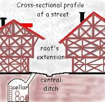
- That roofs for pigs, wooden or stony benches do not remain in any straight street.
- That all the heaps of garbage which are in the dark hidden recesses do not remain in any the aforementioned streets and nobody has the right to let new more.
- That in any of Béziers's straight streets no man goes to throw either to accumulate fertilizer or straw.
- That any bumps of the aforementioned straight streets' ground are levelled by means of removal of ground, to equalize the level.
- That nobody makes a garbage dump in front of his house, unless he lives in a closed street or in an opened sky's one.
- That no man knifes any animal, pig either ox, or sheep, or billy goat, in a public straight street, as so he will not be in the butcher's shop.
- That no man melts some tallow in the city of Béziers.
- That no man beats or sieves wheat in sheaves in the straight streets.
- That no man establishes lean-tos, holds tubs, either jars of plants outside forjets (roof's prolongation), or on Béziers's windows.
- That any heap of stones, wooden pieces being able to be a cause of danger or damage has to be destroyed, or has to be leveled for not to be a cause nor possibility of damage.
- That no man either any woman establishes fences, or fertilizer's hollow, or lairans (tub, container), or makes washings, or cloth lines on the ramparts.
